Anacostia Riverwalk Trail
centroid 4 mi from Washington
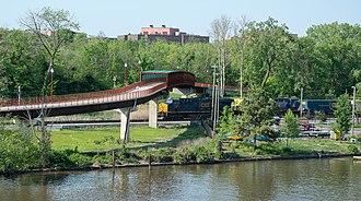
The Anacostia Riverwalk Trail is a paved multi-use trail that runs along the Anacostia River. It is free and is open year-round during daylight hours. The trail is excellent for biking, jogging and walking.
Pets are welcome along the trail as long as they are on a 6 foot or shorter leash. The trail is 3.5 miles long in Anacostia Park, but you have many options to extend your journey. You can do a 7.8 mile loop by crossing the Anacostia River and riding along the west bank or the river.
You can also continue along the trail north to Bladensburg Park in Maryland, or south by going across one of the bridges into downtown DC to the Capitol Hill and Navy Yard neighborhoods. Local attractions along the trail in Anacostia Park include the Anacostia Park Pavillion, where you can rent roller-skates from Memorial Day until Labor Day. The Anacostia Pool, tennis courts, basketball courts and many athletic fields provide the opportunity for sports and recreation.
- States
- DC
- Trail type
- Park trail
- Centroid nearest city
- Washington, DC · 4 mi · ~5 min drive
- Centroid coords
- 38.8792°, -76.9708°
About Anacostia Park
This trail is inside Anacostia Park, a park managed by the U.S. National Park Service. Conditions, road status, trail closures, and reservation requirements are published on the park's NPS page — check it before driving in, especially in winter or during major weather events.
Official NPS trail page: https://www.nps.gov/places/anacostia-riverwalk-trail.htm
Park homepage: https://www.nps.gov/anac/index.htm
Plan your hike
Maps + permits: long-distance trails like this often require permits for through-hiking, backcountry camping, or specific sections (especially in National Parks). Check with the maintaining organisation listed above and the relevant land manager before booking travel.
Water + supplies: water sources vary seasonally on most U.S. trails. Carry a filter and consult current trail-condition reports — through-hiker journals (PCT-L, AT Reddit, etc.) and the maintaining organisation publish regular updates.
When to go: hiking seasons vary widely with elevation, latitude, and snowpack. Through-hikers traditionally start the AT in March-April (Springer northbound) and the PCT in late April (Campo northbound). High-elevation western trails (CDT, JMT, Wonderland) generally aren't passable until July.
If you've hiked Anacostia Riverwalk Trail and have current notes (water sources, trail closures, permit changes), tell us at /contact — we update pages as we learn.
Stay nearby
Other trails within 50 miles
ADT - Maryland - Seg 3
5 miles from this trail's centroid
Mount Vernon Trail North Terminus
5 miles from this trail's centroid
Information Panel: The Path to Freedom
5 miles from this trail's centroid
Capital Crescent Trail terminus
6 miles from this trail's centroid
Rachel Carson Greenway Trail
9 miles from this trail's centroid
Azalea Trail
9 miles from this trail's centroid
Sources
Trail data on this page is compiled from OpenStreetMap contributors (ODbL), the maintaining organisation's public-facing materials, and Wikipedia (CC BY-SA where excerpts are quoted). Distance, terminus, and descriptive text for nationally-designated trails are hand-curated from federal land-manager websites and trail-association sources. We do not modify the underlying data; this page presents what is already publicly recorded. To suggest corrections, see our methodology page.