Find your next outdoor adventure.
A free, fact-checked guide to America's outdoor places — built city by city. We catalogue waterfalls, hot springs, and named hiking trails across all 50 states with location, drive-times, and access notes. Swimming holes, kayak access, and more rolling out through 2026.
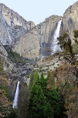
Featured falls
Iconic falls with rich documentation — a starting point if you don't know what you're looking for yet.
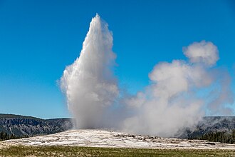
Featured hot springs
From Yellowstone's geysers to Big Bend's riverside soaking pools — the most documented thermal features in our database. Browse all 1,391 catalogued thermal features →
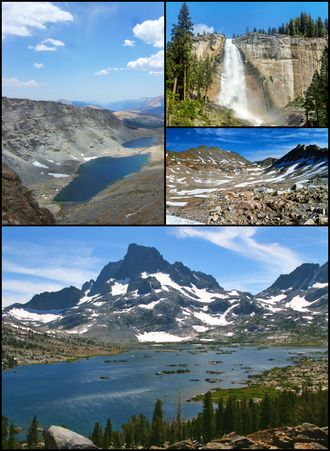
Featured hiking trails
America's 11 National Scenic Trails plus the famous regional long-distance routes — from the 2,650-mile Pacific Crest Trail to the 93-mile Wonderland loop around Mount Rainier. Browse all 13,359 catalogued trails →
Browse by state
Every named waterfall, hot spring, and hiking trail in our database, by state. Switch tabs to change category. The accent stripe shows the region.
Top cities for waterfall trips
Cities with the most waterfalls within a 75-mile drive. Useful if you're planning a weekend.
Asheville
Drive-time and access notes for waterfalls reachable from Asheville.
Greenville
Drive-time and access notes for waterfalls reachable from Greenville.
Portland
Drive-time and access notes for waterfalls reachable from Portland.
Seattle
Drive-time and access notes for waterfalls reachable from Seattle.
Albany
Drive-time and access notes for waterfalls reachable from Albany.
Chattanooga
Drive-time and access notes for waterfalls reachable from Chattanooga.
Top cities for hot-springs trips
Hot-spring density tells a different story than waterfalls — the Rocky Mountain, Great Basin, and Cascades regions dominate. Boise, Bozeman, and Reno are the obvious soaking-trip basecamps.
Bozeman
Drive-time and access notes for hot springs reachable from Bozeman.
Boise
Drive-time and access notes for hot springs reachable from Boise.
Reno
Drive-time and access notes for hot springs reachable from Reno.
Seattle
Drive-time and access notes for hot springs reachable from Seattle.
Las Vegas
Drive-time and access notes for hot springs reachable from Las Vegas.
Colorado Springs
Drive-time and access notes for hot springs reachable from Colorado Springs.
Top cities for hiking trips
Cities with the most named hiking trails reachable within a 75-mile drive of the metro. Reflects OpenStreetMap contributor density as much as actual trail availability — the Northeast over-indexes on local trail mapping.
Seattle
Hiking trails reachable from Seattle (centroid within 75 mi).
New York
Hiking trails reachable from New York (centroid within 75 mi).
Hartford
Hiking trails reachable from Hartford (centroid within 75 mi).
Bridgeport
Hiking trails reachable from Bridgeport (centroid within 75 mi).
Albuquerque
Hiking trails reachable from Albuquerque (centroid within 75 mi).
Washington
Hiking trails reachable from Washington (centroid within 75 mi).
How RoamFound is built
Every place in our database is sourced from public records — the U.S. Geological Survey's Geographic Names Information System, OpenStreetMap contributors, the National Park Service, and Wikipedia. We don't pay anyone to be listed, and we don't accept payment to manipulate rankings.
Where we earn revenue, it's transparent: contextual links to accommodation if you're driving in from out of town (we earn a small commission, you don't pay more), and ads on some pages. Read more on the methodology page.
Get notified when more places launch in your area.
We're rolling out new categories city by city — hiking trails, swimming holes, kayaking access points are next on the roadmap. Drop your email and we'll let you know when something opens near you.
Your address is stored securely and used only for occasional category-launch notifications. Unsubscribe any time at /contact.