Wonderland Trail
93 mi long · in Washington · centroid 58 mi from Seattle
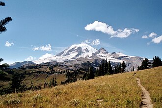
The Wonderland Trail is a 93-mile loop circling Mount Rainier in Washington's Mount Rainier National Park. With approximately 22,000 feet of cumulative elevation gain, it is one of the most demanding long-distance trails in the National Park system. Permits are required for backcountry camping and are highly competitive.
- States
- Washington
- Length
- 93 mi
- Trail type
- Long-distance trail
- Network
- Regional (rwn)
- Centroid nearest city
- Seattle, WA · 58 mi · ~1.7 hr drive
- Centroid coords
- 46.8618°, -121.7588°
- OSM relations
- 1 sub-relations on OpenStreetMap
Termini
Loop: 93-mile loop around Mount Rainier.
Plan your hike
Maps + permits: long-distance trails like this often require permits for through-hiking, backcountry camping, or specific sections (especially in National Parks). Check with the maintaining organisation listed above and the relevant land manager before booking travel.
Water + supplies: water sources vary seasonally on most U.S. trails. Carry a filter and consult current trail-condition reports — through-hiker journals (PCT-L, AT Reddit, etc.) and the maintaining organisation publish regular updates.
When to go: hiking seasons vary widely with elevation, latitude, and snowpack. Through-hikers traditionally start the AT in March-April (Springer northbound) and the PCT in late April (Campo northbound). High-elevation western trails (CDT, JMT, Wonderland) generally aren't passable until July.
If you've hiked Wonderland Trail and have current notes (water sources, trail closures, permit changes), tell us at /contact — we update pages as we learn.
Stay nearby
Other trails within 50 miles
Paradise Trails Orientation: Pebble Creek & Pebble Creek Spur Trail Junction
4 miles from this trail's centroid
Paradise Trails Orientation: Pebble Creek Spur & Skyline Trail Junction
4 miles from this trail's centroid
Paradise Trails Orientation: Skyline & Lower Pebble Creek Trail Junction
4 miles from this trail's centroid
Paradise Trails Orientation: Skyline & Upper Glacier Vista Trail Junction
4 miles from this trail's centroid
Paradise Trails Orientation: Skyline & Lower Glacier Vista Trail Junction
4 miles from this trail's centroid
Paradise Trails Orientation: Skyline & Upper Deadhorse Creek Trail Junction
5 miles from this trail's centroid
Sources
Trail data on this page is compiled from OpenStreetMap contributors (ODbL), the maintaining organisation's public-facing materials, and Wikipedia (CC BY-SA where excerpts are quoted). Distance, terminus, and descriptive text for nationally-designated trails are hand-curated from federal land-manager websites and trail-association sources. We do not modify the underlying data; this page presents what is already publicly recorded. To suggest corrections, see our methodology page.