John Muir Trail
211 mi long · in California · centroid 58 mi from Fresno
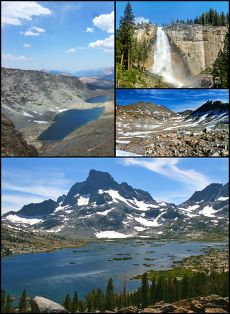
The John Muir Trail runs 211 miles through California's Sierra Nevada from Yosemite Valley to the summit of Mount Whitney (the highest point in the contiguous United States). It shares much of its route with the Pacific Crest Trail and is named for the Scottish-American naturalist John Muir. The trail crosses the heart of three national parks (Yosemite, Kings Canyon, and Sequoia) and is widely considered one of the most scenic long-distance trails in North America.
- States
- California
- Length
- 211 mi
- Trail type
- Long-distance trail
- Network
- Regional (rwn)
- Centroid nearest city
- Fresno, CA · 58 mi · ~1.7 hr drive
- Centroid coords
- 37.2155°, -118.9250°
- Official site
- www.pcta.org/discover-the-trail/john-muir-trail
- OSM relations
- 1 sub-relations on OpenStreetMap
Termini
Southern terminus: Whitney Portal, California.
Northern terminus: Yosemite Valley, California.
Plan your hike
Maps + permits: long-distance trails like this often require permits for through-hiking, backcountry camping, or specific sections (especially in National Parks). Check with the maintaining organisation listed above and the relevant land manager before booking travel.
Water + supplies: water sources vary seasonally on most U.S. trails. Carry a filter and consult current trail-condition reports — through-hiker journals (PCT-L, AT Reddit, etc.) and the maintaining organisation publish regular updates.
When to go: hiking seasons vary widely with elevation, latitude, and snowpack. Through-hikers traditionally start the AT in March-April (Springer northbound) and the PCT in late April (Campo northbound). High-elevation western trails (CDT, JMT, Wonderland) generally aren't passable until July.
If you've hiked John Muir Trail and have current notes (water sources, trail closures, permit changes), tell us at /contact — we update pages as we learn.
Stay nearby
Other trails within 50 miles
Theodore Solomons Trail
13 miles from this trail's centroid
North Lake South Lake Loop
13 miles from this trail's centroid
Rae Lakes Loop
37 miles from this trail's centroid
San Joaquin River Trail
39 miles from this trail's centroid
Big SEKI Loop
39 miles from this trail's centroid
Big Trees Loop - The Fallen Monarch
42 miles from this trail's centroid
Sources
Trail data on this page is compiled from OpenStreetMap contributors (ODbL), the maintaining organisation's public-facing materials, and Wikipedia (CC BY-SA where excerpts are quoted). Distance, terminus, and descriptive text for nationally-designated trails are hand-curated from federal land-manager websites and trail-association sources. We do not modify the underlying data; this page presents what is already publicly recorded. To suggest corrections, see our methodology page.