Centennial Trail
in South Dakota
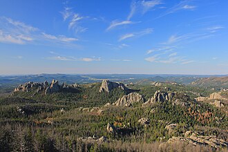
Centennial Trail is hiking trail in South Dakota. This page summarises what we have from public sources (OpenStreetMap and trail-association data); always verify current conditions and trail status with the maintaining organisation before heading out.
- States
- South Dakota
- Network
- Regional (rwn)
- Reference
- CT
- Centroid coords
- 44.0290°, -103.4904°
- OSM relation
- 7330792
Plan your hike
Maps + permits: long-distance trails like this often require permits for through-hiking, backcountry camping, or specific sections (especially in National Parks). Check with the maintaining organisation listed above and the relevant land manager before booking travel.
Water + supplies: water sources vary seasonally on most U.S. trails. Carry a filter and consult current trail-condition reports — through-hiker journals (PCT-L, AT Reddit, etc.) and the maintaining organisation publish regular updates.
When to go: hiking seasons vary widely with elevation, latitude, and snowpack. Through-hikers traditionally start the AT in March-April (Springer northbound) and the PCT in late April (Campo northbound). High-elevation western trails (CDT, JMT, Wonderland) generally aren't passable until July.
If you've hiked Centennial Trail and have current notes (water sources, trail closures, permit changes), tell us at /contact — we update pages as we learn.
Other trails within 50 miles
Sources
Trail data on this page is compiled from OpenStreetMap contributors (ODbL), the maintaining organisation's public-facing materials, and Wikipedia (CC BY-SA where excerpts are quoted). Distance, terminus, and descriptive text for nationally-designated trails are hand-curated from federal land-manager websites and trail-association sources. We do not modify the underlying data; this page presents what is already publicly recorded. To suggest corrections, see our methodology page.