Cohos Trail
in New Hampshire · centroid 89 mi from Portland
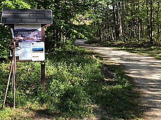
Cohos Trail is hiking trail in New Hampshire maintained by Cohos Trail Association. This page summarises what we have from public sources (OpenStreetMap and trail-association data); always verify current conditions and trail status with the maintaining organisation before heading out.
- States
- New Hampshire
- Network
- Local (lwn)
- Maintained by
- Cohos Trail Association
- Centroid nearest city
- Portland, ME · 89 mi · ~2.6 hr drive
- Centroid coords
- 44.6859°, -71.3504°
- OSM relation
- 14765821
Plan your hike
Maps + permits: long-distance trails like this often require permits for through-hiking, backcountry camping, or specific sections (especially in National Parks). Check with the maintaining organisation listed above and the relevant land manager before booking travel.
Water + supplies: water sources vary seasonally on most U.S. trails. Carry a filter and consult current trail-condition reports — through-hiker journals (PCT-L, AT Reddit, etc.) and the maintaining organisation publish regular updates.
When to go: hiking seasons vary widely with elevation, latitude, and snowpack. Through-hikers traditionally start the AT in March-April (Springer northbound) and the PCT in late April (Campo northbound). High-elevation western trails (CDT, JMT, Wonderland) generally aren't passable until July.
If you've hiked Cohos Trail and have current notes (water sources, trail closures, permit changes), tell us at /contact — we update pages as we learn.
Stay nearby
Other trails within 50 miles
Gore Mountain East Trail
26 miles from this trail's centroid
Bluff Mountain Community Trail
28 miles from this trail's centroid
Basin Link
28 miles from this trail's centroid
Lookout Trail
28 miles from this trail's centroid
Bluff Ridge Trail
28 miles from this trail's centroid
Gore Mountain Trail
29 miles from this trail's centroid
Sources
Trail data on this page is compiled from OpenStreetMap contributors (ODbL), the maintaining organisation's public-facing materials, and Wikipedia (CC BY-SA where excerpts are quoted). Distance, terminus, and descriptive text for nationally-designated trails are hand-curated from federal land-manager websites and trail-association sources. We do not modify the underlying data; this page presents what is already publicly recorded. To suggest corrections, see our methodology page.