International Appalachian Trail
1,900 mi long · in Maine
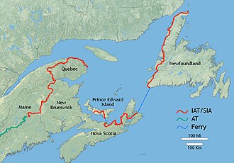
The International Appalachian Trail extends the Appalachian Trail northward from Mount Katahdin in Maine through New Brunswick, Quebec, and Newfoundland, then continues across the North Atlantic into Greenland, Iceland, the British Isles, and the European Appalachian remnants. Total length depends on which European extensions you count; the New England-Canada section alone is roughly 1,900 miles.
- States
- Maine
- Length
- 1,900 mi
- Trail type
- International long-distance trail
- Network
- International (iwn)
- Centroid coords
- 46.9534°, -67.7928°
- Official site
- www.iat-sia.org
- OSM relations
- 1 sub-relations on OpenStreetMap
Termini
Southern terminus: Mount Katahdin, Maine.
Northern terminus: Crow Head, Newfoundland (and continuing in Europe).
Plan your hike
Maps + permits: long-distance trails like this often require permits for through-hiking, backcountry camping, or specific sections (especially in National Parks). Check with the maintaining organisation listed above and the relevant land manager before booking travel.
Water + supplies: water sources vary seasonally on most U.S. trails. Carry a filter and consult current trail-condition reports — through-hiker journals (PCT-L, AT Reddit, etc.) and the maintaining organisation publish regular updates.
When to go: hiking seasons vary widely with elevation, latitude, and snowpack. Through-hikers traditionally start the AT in March-April (Springer northbound) and the PCT in late April (Campo northbound). High-elevation western trails (CDT, JMT, Wonderland) generally aren't passable until July.
If you've hiked International Appalachian Trail and have current notes (water sources, trail closures, permit changes), tell us at /contact — we update pages as we learn.
Sources
Trail data on this page is compiled from OpenStreetMap contributors (ODbL), the maintaining organisation's public-facing materials, and Wikipedia (CC BY-SA where excerpts are quoted). Distance, terminus, and descriptive text for nationally-designated trails are hand-curated from federal land-manager websites and trail-association sources. We do not modify the underlying data; this page presents what is already publicly recorded. To suggest corrections, see our methodology page.