Natchez Trace National Scenic Trail
444 mi long · across 3 states
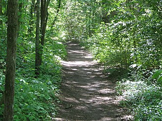
The Natchez Trace National Scenic Trail follows the historic Old Natchez Trace from Natchez, Mississippi to Nashville, Tennessee — roughly 444 miles, though only about 65 miles of trail are currently completed in five disjoint sections paralleling the Natchez Trace Parkway. Designated in 1983, it traces a path used by Native Americans, traders, and 'Kaintucks' floating goods down the Mississippi.
- States
- Mississippi, Alabama, Tennessee
- Length
- 444 mi
- Trail type
- National Scenic Trail
- Network
- National (nwn)
- Centroid nearest city
- Memphis, TN · 101 mi · ~2.9 hr drive
- Centroid coords
- 34.1280°, -88.7732°
- Official site
- www.nps.gov/natt
- OSM relations
- 3 sub-relations on OpenStreetMap
Termini
Southern terminus: Natchez, Mississippi.
Northern terminus: Nashville, Tennessee.
Plan your hike
Maps + permits: long-distance trails like this often require permits for through-hiking, backcountry camping, or specific sections (especially in National Parks). Check with the maintaining organisation listed above and the relevant land manager before booking travel.
Water + supplies: water sources vary seasonally on most U.S. trails. Carry a filter and consult current trail-condition reports — through-hiker journals (PCT-L, AT Reddit, etc.) and the maintaining organisation publish regular updates.
When to go: hiking seasons vary widely with elevation, latitude, and snowpack. Through-hikers traditionally start the AT in March-April (Springer northbound) and the PCT in late April (Campo northbound). High-elevation western trails (CDT, JMT, Wonderland) generally aren't passable until July.
If you've hiked Natchez Trace National Scenic Trail and have current notes (water sources, trail closures, permit changes), tell us at /contact — we update pages as we learn.
Other trails within 50 miles
Sources
Trail data on this page is compiled from OpenStreetMap contributors (ODbL), the maintaining organisation's public-facing materials, and Wikipedia (CC BY-SA where excerpts are quoted). Distance, terminus, and descriptive text for nationally-designated trails are hand-curated from federal land-manager websites and trail-association sources. We do not modify the underlying data; this page presents what is already publicly recorded. To suggest corrections, see our methodology page.