New England National Scenic Trail
in Massachusetts · centroid 24 mi from Hartford
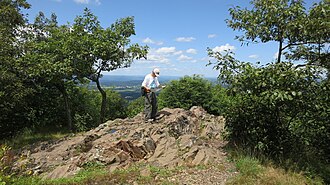
The New England National Scenic Trail (NET) is a 215-mile hiking trail route that has been in existence for over half a century. The NET travels through 41 communities in Connecticut and Massachusetts, and is comprised primarily of the historic Mattabesett, Metacomet, and Monadnock (M-M-M) Trail systems. The NET travels through classic New England landscape features: long-distance vistas with rural towns as a backdrop, agrarian lands, un-fragmented forests, and large river valleys.
The trail also travels through colonial historical landmarks and highlights a range of diverse ecosystems and natural resources: mountain ridges and summits, forested glades, wetlands and vernal pools, lakes, streams and waterfalls. The NET was designated on March 30, 2009 as part of Public Law 111-11 (Section 5202). The law references the Trail Management Blueprint described in the report titled the ‘Metacomet Monadnock Mattabesett Trail System National Scenic Trail Feasibility Study and Environmental Assessment’, prepared by the National Park Service, and dated Spring 2006, as the framework for trail management and administration.
Since the federal designation in 2009, there have been some noteworthy changes to the historic route, including a 4-mile extension to Long Island Sound in Connecticut and a 22+ mile eastward deviation from the historic Metacomet-Monadnock Trail in Massachusetts.
- States
- Massachusetts
- Trail type
- National Scenic Trail trail
- Centroid nearest city
- Hartford, CT · 24 mi · ~40 min drive
- Centroid coords
- 42.1111°, -72.6871°
About New England National Scenic Trail
This trail is inside New England National Scenic Trail, a national scenic trail managed by the U.S. National Park Service. Conditions, road status, trail closures, and reservation requirements are published on the park's NPS page — check it before driving in, especially in winter or during major weather events.
Official NPS trail page: https://www.nps.gov/places/new-england-national-scenic-trail.htm
Park homepage: https://www.nps.gov/neen/index.htm
Plan your hike
Maps + permits: long-distance trails like this often require permits for through-hiking, backcountry camping, or specific sections (especially in National Parks). Check with the maintaining organisation listed above and the relevant land manager before booking travel.
Water + supplies: water sources vary seasonally on most U.S. trails. Carry a filter and consult current trail-condition reports — through-hiker journals (PCT-L, AT Reddit, etc.) and the maintaining organisation publish regular updates.
When to go: hiking seasons vary widely with elevation, latitude, and snowpack. Through-hikers traditionally start the AT in March-April (Springer northbound) and the PCT in late April (Campo northbound). High-elevation western trails (CDT, JMT, Wonderland) generally aren't passable until July.
If you've hiked New England National Scenic Trail and have current notes (water sources, trail closures, permit changes), tell us at /contact — we update pages as we learn.
Stay nearby
Other trails within 50 miles
New England National Scenic Trail
13 miles from this trail's centroid
Clam River Loop
21 miles from this trail's centroid
Clam River Trail
21 miles from this trail's centroid
Hammertown Loop
22 miles from this trail's centroid
Metacomet Trail
22 miles from this trail's centroid
Robert Frost Trail
23 miles from this trail's centroid
Sources
Trail data on this page is compiled from OpenStreetMap contributors (ODbL), the maintaining organisation's public-facing materials, and Wikipedia (CC BY-SA where excerpts are quoted). Distance, terminus, and descriptive text for nationally-designated trails are hand-curated from federal land-manager websites and trail-association sources. We do not modify the underlying data; this page presents what is already publicly recorded. To suggest corrections, see our methodology page.