Summerland Trail Shelter
in Washington · centroid 60 mi from Seattle
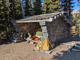
Season: Summer The Summerland Trail Shelter is one of the two Civilian Conservation Corps constructed stone masonry trail shelters in the park. It is located on the east side of the park along the Wonderland Trail, accessible from Fryingpan Creek three miles past the White River entrance. The shelter was designed in 1931, by the NPS Branch of Plans and Design under the supervision of Associate Structural Engineer Edwin A.
Nickel. It was constructed in 1934 by the Civilian Conservation Corps as an Emergency Conservation Work project. The supervisory landscape architect overseeing the construction remarked, "The workmen were inexperienced in stone work and the shelter was not too good in appearance, but it was in harmony with its location." It was one of the numerous trail shelters constructed along the Wonderland Trail, a policy that began under Superintendent Roger W.
Toll (1919-20) and expanded during the superintendency of Major O.A. Tomlinson (1923-1941).
- States
- Washington
- Trail type
- National Park trail
- Centroid nearest city
- Seattle, WA · 60 mi · ~1.7 hr drive
- Centroid coords
- 46.8652°, -121.6589°
About Mount Rainier National Park
This trail is inside Mount Rainier National Park, a national park managed by the U.S. National Park Service. Conditions, road status, trail closures, and reservation requirements are published on the park's NPS page — check it before driving in, especially in winter or during major weather events.
Entrance fee: $30 per vehicle (verify current rate on the park page). An America the Beautiful annual pass ($80) covers entrance to all NPS units.
Official NPS trail page: https://www.nps.gov/places/summerland-trail-shelter.htm
Park homepage: https://www.nps.gov/mora/index.htm
Plan your hike
Maps + permits: long-distance trails like this often require permits for through-hiking, backcountry camping, or specific sections (especially in National Parks). Check with the maintaining organisation listed above and the relevant land manager before booking travel.
Water + supplies: water sources vary seasonally on most U.S. trails. Carry a filter and consult current trail-condition reports — through-hiker journals (PCT-L, AT Reddit, etc.) and the maintaining organisation publish regular updates.
When to go: hiking seasons vary widely with elevation, latitude, and snowpack. Through-hikers traditionally start the AT in March-April (Springer northbound) and the PCT in late April (Campo northbound). High-elevation western trails (CDT, JMT, Wonderland) generally aren't passable until July.
If you've hiked Summerland Trail Shelter and have current notes (water sources, trail closures, permit changes), tell us at /contact — we update pages as we learn.
Stay nearby
Other trails within 50 miles
Indian Bar Trail Shelter
3 miles from this trail's centroid
Sunrise Nature Trail Stop 1
4 miles from this trail's centroid
Sunrise Nature Trail Stop 2
4 miles from this trail's centroid
Sunrise Nature Trail Stop 3
4 miles from this trail's centroid
Sunrise Nature Trail Stop 4
4 miles from this trail's centroid
Sunrise Nature Trail Stop 13
4 miles from this trail's centroid
Sources
Trail data on this page is compiled from OpenStreetMap contributors (ODbL), the maintaining organisation's public-facing materials, and Wikipedia (CC BY-SA where excerpts are quoted). Distance, terminus, and descriptive text for nationally-designated trails are hand-curated from federal land-manager websites and trail-association sources. We do not modify the underlying data; this page presents what is already publicly recorded. To suggest corrections, see our methodology page.