Trail of the Cedars
in Montana
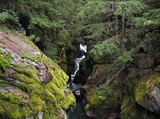
Trail of the Cedars is a peaceful boardwalk nature trail along Avalanche Creek. Follow the boardwalk through old growth cedars, listen to the American dippers, and see the powerful force of water carving the Avalanche Gorge. Trail of the Cedars 0.9 mi (1.1 km) loop Elevation gain: 83 ft (25 m) Elevation loss: 83 ft (25 m) Trailhead: Avalanche Picnic Area While in Glacier National Park, please maintain extra awareness around water, steep dropoffs, and wildlife.
You are responsible for your own safety.
- States
- Montana
- Trail type
- National Park trail
- Centroid nearest city
- Spokane, WA · 181 mi · ~5 hr drive
- Centroid coords
- 48.6806°, -113.8188°
About Glacier National Park
This trail is inside Glacier National Park, a national park managed by the U.S. National Park Service. Conditions, road status, trail closures, and reservation requirements are published on the park's NPS page — check it before driving in, especially in winter or during major weather events.
Entrance fee: $35 per vehicle (verify current rate on the park page). An America the Beautiful annual pass ($80) covers entrance to all NPS units.
Official NPS trail page: https://www.nps.gov/places/trail-of-the-cedars.htm
Park homepage: https://www.nps.gov/glac/index.htm
Plan your hike
Maps + permits: long-distance trails like this often require permits for through-hiking, backcountry camping, or specific sections (especially in National Parks). Check with the maintaining organisation listed above and the relevant land manager before booking travel.
Water + supplies: water sources vary seasonally on most U.S. trails. Carry a filter and consult current trail-condition reports — through-hiker journals (PCT-L, AT Reddit, etc.) and the maintaining organisation publish regular updates.
When to go: hiking seasons vary widely with elevation, latitude, and snowpack. Through-hikers traditionally start the AT in March-April (Springer northbound) and the PCT in late April (Campo northbound). High-elevation western trails (CDT, JMT, Wonderland) generally aren't passable until July.
If you've hiked Trail of the Cedars and have current notes (water sources, trail closures, permit changes), tell us at /contact — we update pages as we learn.
Other trails within 50 miles
Avalanche Lake Trail
0 miles from this trail's centroid
The Loop
5 miles from this trail's centroid
St. Mary Falls Trail
9 miles from this trail's centroid
Redrock Falls Trail
10 miles from this trail's centroid
Apikuni Falls Trail
12 miles from this trail's centroid
Forest and Fire Nature Trail
15 miles from this trail's centroid
Sources
Trail data on this page is compiled from OpenStreetMap contributors (ODbL), the maintaining organisation's public-facing materials, and Wikipedia (CC BY-SA where excerpts are quoted). Distance, terminus, and descriptive text for nationally-designated trails are hand-curated from federal land-manager websites and trail-association sources. We do not modify the underlying data; this page presents what is already publicly recorded. To suggest corrections, see our methodology page.