California · Documented attraction
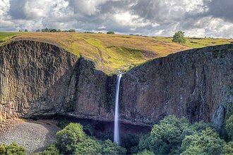
Phantom Falls
71 mi from Sacramento · ~2.1 hr drive · Intermittent
164ft tall
≈ 50 m
≈ 50 m
71 mi from Sacramento · ~2.1 hr drive · Intermittent
Intermittent waterfall at North Table Mountain. There is a shallow cave behind it at the bottom of the canyon, and an abandoned mine shaft that has been filled in.
The exact location is at 39.6105°, -121.5607° — open in Google Maps for driving directions from your location.
Before you go: check current conditions with the appropriate land manager — state parks department, U.S. Forest Service ranger district, or National Park Service unit. Trail access, parking, water levels, and seasonal closures all vary. Several waterfalls in our database are seasonal and may run dry between mid-summer and the next rainy season.
If you've visited Phantom Falls and have current notes (parking situation, dog policy, seasonality, kid-friendliness), tell us at /contact — we update pages as we learn more.
0 miles from Phantom Falls · 124 ft
0 miles from Phantom Falls · 76 ft
0 miles from Phantom Falls · 20 ft
0 miles from Phantom Falls · 46 ft
1 miles from Phantom Falls · 40 ft
1 miles from Phantom Falls
Location and tag data for Phantom Falls comes from OpenStreetMap contributors (ODbL license) ; the Wikipedia article linked above provides additional history. We do not modify the underlying data — this page presents what's already publicly recorded. To suggest corrections, see our methodology page or contact us.