Washington · Mount Rainier National Park
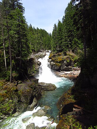
Silver Falls
69 mi from Seattle · ~2.0 hr drive
95ft tall
≈ 29 m
≈ 29 m
69 mi from Seattle · ~2.0 hr drive
Silver Falls is a named waterfall in Washington — a 95-foot drop, about 69 miles from Seattle, WA. Full visit details below.
Silver Falls is inside Mount Rainier National Park, a U.S. National Park managed by the National Park Service. Conditions, road status, trail closures, and reservation requirements are published directly on the park's NPS page — check it before driving in, especially in winter or during major weather events.
Entrance fee: $30 per vehicle. Per vehicle, valid 7 days. Timed-entry reservations required for some entrances in summer. An America the Beautiful annual pass ($80) covers entrance to all NPS units and is worth it after ~3 park visits per year.
Park homepage: https://www.nps.gov/mora/
The exact location is at 46.7523°, -121.5595° — open in Google Maps for driving directions from your location.
Before you go: check current conditions with the appropriate land manager — state parks department, U.S. Forest Service ranger district, or National Park Service unit. Trail access, parking, water levels, and seasonal closures all vary. Several waterfalls in our database are seasonal and may run dry between mid-summer and the next rainy season.
If you've visited Silver Falls and have current notes (parking situation, dog policy, seasonality, kid-friendliness), tell us at /contact — we update pages as we learn more.
Location and tag data for Silver Falls comes from OpenStreetMap contributors (ODbL license) ; the Wikipedia article linked above provides additional history. We do not modify the underlying data — this page presents what's already publicly recorded. To suggest corrections, see our methodology page or contact us.