Bartram Trail
115 mi long · across 2 states · centroid 60 mi from Asheville
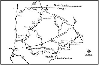
The Bartram Trail traces 115 miles of botanist William Bartram's 1775 journey through the southern Appalachians, from Russell Bridge in Georgia north to Cheoah Bald in the Nantahala National Forest, North Carolina. The trail crosses with the Appalachian Trail at Cheoah Bald.
- States
- Georgia, North Carolina
- Length
- 115 mi
- Trail type
- Long-distance trail
- Network
- Regional (rwn)
- Centroid nearest city
- Asheville, NC · 60 mi · ~1.7 hr drive
- Centroid coords
- 35.0950°, -83.4281°
- Official site
- www.bartramtrail.org
- OSM relations
- 1 sub-relations on OpenStreetMap
Termini
Southern terminus: Russell Bridge, Georgia.
Northern terminus: Cheoah Bald, North Carolina.
Plan your hike
Maps + permits: long-distance trails like this often require permits for through-hiking, backcountry camping, or specific sections (especially in National Parks). Check with the maintaining organisation listed above and the relevant land manager before booking travel.
Water + supplies: water sources vary seasonally on most U.S. trails. Carry a filter and consult current trail-condition reports — through-hiker journals (PCT-L, AT Reddit, etc.) and the maintaining organisation publish regular updates.
When to go: hiking seasons vary widely with elevation, latitude, and snowpack. Through-hikers traditionally start the AT in March-April (Springer northbound) and the PCT in late April (Campo northbound). High-elevation western trails (CDT, JMT, Wonderland) generally aren't passable until July.
If you've hiked Bartram Trail and have current notes (water sources, trail closures, permit changes), tell us at /contact — we update pages as we learn.
Stay nearby
Other trails within 50 miles
Chattooga River Trail
19 miles from this trail's centroid
Benton MacKaye Trail
23 miles from this trail's centroid
Palmetto Trail: Oconee Passage
25 miles from this trail's centroid
Arkaquah Trail
28 miles from this trail's centroid
Lakeshore Trail
29 miles from this trail's centroid
Forney Creek Trail
29 miles from this trail's centroid
Sources
Trail data on this page is compiled from OpenStreetMap contributors (ODbL), the maintaining organisation's public-facing materials, and Wikipedia (CC BY-SA where excerpts are quoted). Distance, terminus, and descriptive text for nationally-designated trails are hand-curated from federal land-manager websites and trail-association sources. We do not modify the underlying data; this page presents what is already publicly recorded. To suggest corrections, see our methodology page.