Foothills Trail
77 mi long · across 2 states · centroid 64 mi from St. Louis
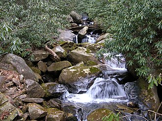
The Foothills Trail traces 77 miles along the Blue Ridge Escarpment between Oconee State Park and Table Rock State Park in South Carolina, briefly crossing into North Carolina. It passes Whitewater Falls (the highest waterfall east of the Mississippi) and follows the wild Chattooga River.
- States
- North Carolina, South Carolina
- Length
- 77 mi
- Trail type
- Long-distance trail
- Network
- Regional (rwn)
- Centroid nearest city
- St. Louis, MO · 64 mi · ~1.9 hr drive
- Centroid coords
- 37.9954°, -89.3268°
- Official site
- foothillstrail.org
- OSM relations
- 2 sub-relations on OpenStreetMap
Termini
Eastern terminus: Table Rock State Park, South Carolina.
Western terminus: Oconee State Park, South Carolina.
Plan your hike
Maps + permits: long-distance trails like this often require permits for through-hiking, backcountry camping, or specific sections (especially in National Parks). Check with the maintaining organisation listed above and the relevant land manager before booking travel.
Water + supplies: water sources vary seasonally on most U.S. trails. Carry a filter and consult current trail-condition reports — through-hiker journals (PCT-L, AT Reddit, etc.) and the maintaining organisation publish regular updates.
When to go: hiking seasons vary widely with elevation, latitude, and snowpack. Through-hikers traditionally start the AT in March-April (Springer northbound) and the PCT in late April (Campo northbound). High-elevation western trails (CDT, JMT, Wonderland) generally aren't passable until July.
If you've hiked Foothills Trail and have current notes (water sources, trail closures, permit changes), tell us at /contact — we update pages as we learn.
Stay nearby
Other trails within 50 miles
Old River to River - Alternate Segment 6 - Giant City to Alto Pass
27 miles from this trail's centroid
River to River Segment 7 - Alto Pass to Devil's Backbone
28 miles from this trail's centroid
River to River Segment 6 - Giant City to Alto Pass
28 miles from this trail's centroid
River to River Segment 5 - Ferne Clyffe to Giant City
33 miles from this trail's centroid
ADT - Illinois (South) - J - Seg 3
33 miles from this trail's centroid
ADT - Illinois (South) - J - Seg 2
38 miles from this trail's centroid
Sources
Trail data on this page is compiled from OpenStreetMap contributors (ODbL), the maintaining organisation's public-facing materials, and Wikipedia (CC BY-SA where excerpts are quoted). Distance, terminus, and descriptive text for nationally-designated trails are hand-curated from federal land-manager websites and trail-association sources. We do not modify the underlying data; this page presents what is already publicly recorded. To suggest corrections, see our methodology page.