Sunset Park Trail Shelter
in Washington · centroid 54 mi from Seattle
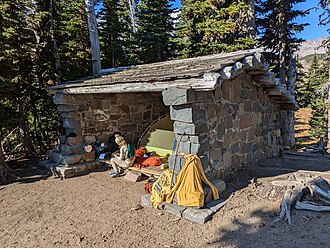
Season: Summer The Sunset Park Trail Shelter is located on the west side of the park along the Wonderland Trail at Golden Lakes. Prior to 1920, there were very few shelters for backcountry hikers and park rangers. Superintendent Toll (1919-20) stressed the need for a string of trail shelters to be placed ten to fifteen miles apart on the popular Wonderland Trail.
Toll's system evolved into the construction of both patrol cabins and trail shelters under Superintendent O. A. Tomlinson's administration (1923-41). By 1924, there were seven known trail shelters in the park.
One was located at Golden Lakes in Sunset Park (Thompson 1981). This pre-1924 shelter must have been demolished, however, the Superintendent's monthly report of October 1931 stated that a trail shelter had been constructed at Sunset Park the previous month.
- States
- Washington
- Trail type
- National Park trail
- Centroid nearest city
- Seattle, WA · 54 mi · ~1.6 hr drive
- Centroid coords
- 46.8830°, -121.8982°
About Mount Rainier National Park
This trail is inside Mount Rainier National Park, a national park managed by the U.S. National Park Service. Conditions, road status, trail closures, and reservation requirements are published on the park's NPS page — check it before driving in, especially in winter or during major weather events.
Entrance fee: $30 per vehicle (verify current rate on the park page). An America the Beautiful annual pass ($80) covers entrance to all NPS units.
Official NPS trail page: https://www.nps.gov/places/sunset-park-trail-shelter.htm
Park homepage: https://www.nps.gov/mora/index.htm
Plan your hike
Maps + permits: long-distance trails like this often require permits for through-hiking, backcountry camping, or specific sections (especially in National Parks). Check with the maintaining organisation listed above and the relevant land manager before booking travel.
Water + supplies: water sources vary seasonally on most U.S. trails. Carry a filter and consult current trail-condition reports — through-hiker journals (PCT-L, AT Reddit, etc.) and the maintaining organisation publish regular updates.
When to go: hiking seasons vary widely with elevation, latitude, and snowpack. Through-hikers traditionally start the AT in March-April (Springer northbound) and the PCT in late April (Campo northbound). High-elevation western trails (CDT, JMT, Wonderland) generally aren't passable until July.
If you've hiked Sunset Park Trail Shelter and have current notes (water sources, trail closures, permit changes), tell us at /contact — we update pages as we learn.
Stay nearby
Other trails within 50 miles
South Mowich Trail Shelter
2 miles from this trail's centroid
Peak Two Trail #268
5 miles from this trail's centroid
Glacier View Trail #267
6 miles from this trail's centroid
Puyallup Trail #248
6 miles from this trail's centroid
Wonderland Trail
7 miles from this trail's centroid
Northern Loop Trail
9 miles from this trail's centroid
Sources
Trail data on this page is compiled from OpenStreetMap contributors (ODbL), the maintaining organisation's public-facing materials, and Wikipedia (CC BY-SA where excerpts are quoted). Distance, terminus, and descriptive text for nationally-designated trails are hand-curated from federal land-manager websites and trail-association sources. We do not modify the underlying data; this page presents what is already publicly recorded. To suggest corrections, see our methodology page.